[Most Recent Entries] [Calendar View] [Friends View]
Tuesday, October 10th, 2023
| Time | Event |
| 2:05p | |
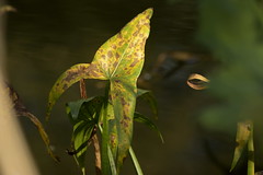
| 2:05p | Arrowhead Tony Tooth has added a photo to the pool:
An Arrowhead leaf (Sagittaria sagittifolia) in the Macclesfield Canal near Gawsworth, Cheshire |
| 2:05p | |
| 2:05p | Autumn colour, Sweet Chestnuts on the woodland floor favmark1 has added a photo to the pool:
With the weather still being totally bonkers it's elongated the cycling season so back in the saddle for some gorgeous autumnal cycle rides through the beautiful Kent countryside and some rather special finds, all will be revealed later!!! |
| 2:05p | |
| 2:05p | |
| 2:05p | |
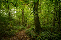
| 2:05p | _R002172 mrdaveyoung has added a photo to the pool:
Out in the woods with the Ricoh GR3 - am I mad?! |
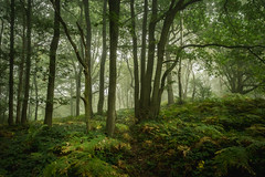
| 2:05p | _R002157 mrdaveyoung has added a photo to the pool:
Out in the woods with the Ricoh GR3 - am I mad?! |
| 2:05p | _R002150 mrdaveyoung has added a photo to the pool:
Out in the woods with the Ricoh GR3 - am I mad?! |
| 2:05p | |
| 2:05p | |
| 2:05p | |
| 2:05p | |
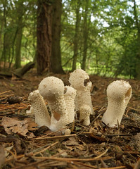
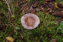
| 2:05p | Pestle puffball Maureencampbellphotography has added a photo to the pool:
Thank you all who fave and comment on my photo'/video's,much appreciated |
| 2:05p | |
| 2:05p | |
| 2:05p | |
| 2:05p | |
| 2:05p | Kyle of Durness, Sutherland, Scotland, evening Jim 592 has added a photo to the pool:
Despite the name Sutherland, this region is in the north of Scotland. The name was given by the Vikings, for whom it lay of course in a southerly direction. |
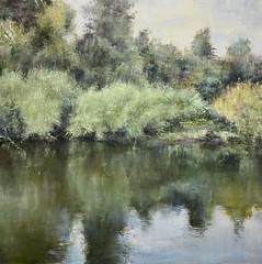
| 2:35p | On the Other Side of Silence - Oil on Canvas - 80 x 80 cm - available www.sandragraham.co.uk has added a photo to the pool:
On the Other Side of Silence - Oil on canvas - 80 x 80 cm -available |
| 4:09p | |
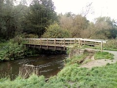
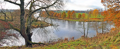
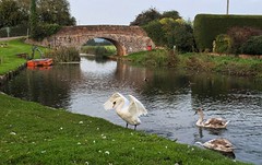
| 4:09p | Countryside view, Cheshire g.w.mason has added a photo to the pool:
Taken in riverside park and nature reserve, tyherington, near Macclesfield, Cheshire, bridge over the river bollin |
| 4:09p | |
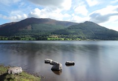
| 4:09p | December Derwentwater greengrocer48 has added a photo to the pool:
Late afternoon, temperature and light dropping. |
| 4:09p | |
| 4:09p | |
| 4:39p | |
| 4:39p | Ready2Roll Tony Tooth has added a photo to the pool:
With the death of HS2 north of Birmingham, the eventual reopening of this line from Stoke to Leek has been confirmed. Here at Longsdon, Staffordshire |
| 4:39p | Joe Rook mark.griffin52 has added a photo to the pool:
Walk along the coast path from Lulworth Cove to Durdle Door. |
| 5:09p | |
| 5:09p | |
| 5:09p | |
| 5:39p | |
| 5:39p | Confluence. greengrocer48 has added a photo to the pool:
The meeting of the Rivers Eden and Eamont. |
| 5:39p | Thatched Barn mark.griffin52 has added a photo to the pool:
A quick stop in the car at Whitcombe, just outside Dorchester. |
| 5:39p | Sunset at Maiden Castle mark.griffin52 has added a photo to the pool:
Sunset visit to Maidenhead Castle - Iron Age hill fort. |
| 5:39p | "Even the most Beautiful Flower, Must Carry the Curse to Wilt..." Stuey2008 has added a photo to the pool:
|
| 6:09p | Confluence 2 greengrocer48 has added a photo to the pool:
The meeting of the River Eamont and the River Eden. The Eden flows from left to right across the frame. |
| 6:09p | |
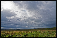
| 6:39p | Sharing a Roman soldier's view of Northumbrian clouds David- 80 has added a photo to the pool:
There is no doubt that Roman soldiers stood at this very spot and also looked up at threatening Northumbrian clouds. The photo was taken from inside one of the forts which had housed Roman soldiers tasked with defending Hadrian's Wall. Today the site is called Carrawburgh Fort but the Roman's knew it as Brocolitia. The fort itself has never been fully excavated except briefly in the late 1800's, although more recently there has been the discovery, just outside the walls, of a temple to Mithras (god of soldiers) and shrines to local water spirits. The fort's site is easy to see as a series of lumps and bumps and is reckoned to be the best preserved fort. It housed about 500 troops from 130AD until the Romans abandoned the whole province in 440 AD. Outside the fort was the usual Vicus, a civilian settlement catering for the needs of soldiers and included provision for visitors, families, retired soldiers, as well as the various traders the military the world over attracts. There were not many actual Roman soldiers, most were Auxiliary troops recruited from other parts of the Empire or even outside it. Here, at times, were troops from South-West France, the Low Countries, and even Eastern Germany. |
| 6:39p | |
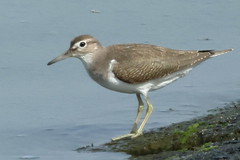
| 7:39p | Common Nettle 4975 Mike Thornton 15 has added a photo to the pool:
Also known as the Stinging Nettle. First outing to test my Canon R5. Still plenty to learn but it did ok so far. Taken down alongside the River Goyt near Chadkirk Woods. Only ambient light used. The veins on this particular specimen really stood out. Well known to all countryside walkers. The small needle like hollow hairs break at the slightest touch and release an irritating fluid. This was not focus bracketed using the in-camera feature. |
| 7:39p | |
| 8:09p | Passage to Derwent Isle. greengrocer48 has added a photo to the pool:
A nearly frozen Derwentwater in the Winter of 2010. |
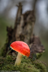
| 8:09p | Fly Agaric 4752 (Amanita muscaria) Mike Thornton 15 has added a photo to the pool:
A striking red cap fungi that is extremely toxic and can cause severe symptoms if eaten. This young domed specimen will flatten as it matures and was one of several in Bolehill Quarry, Derbyshire. Unfortunately most had been nibbled at and there were very few full specimens. Not surprising at the numbers when one considers that the quarry contains a significant number of Silver Birch trees. |
| 8:09p | |
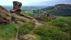
| 8:09p | Farms in the Forest of Bowland, North Yorkshire Baz Richardson - now away has added a photo to the pool:
The Forest of Bowland, also known as the Bowland Fells and formerly the Chase of Bowland, is a beautiful area of gritstone fells, deep valleys and peat moorland, mostly in the north of Lancashire, with the north-eastern part of the Forest of Bowland (pictured here) being just over the border in North Yorkshire. Numerous farms dot the landscape. |
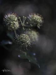
| 9:42p | Ivy flowers_P7A6847 Wendy Ball - West Sussex has added a photo to the pool:
Ivy begins to produce yellow/green, strong-smelling blooms when a lot of flowering plants are starting to die off in late summer, so it is an essential food plant for pollinators when there is little else about. It is particularly important to many insects before they go into hibernation. Some of the main insect species which forage on the nectar and pollen of ivy are bees, hoverflies and common wasps. The Ivy Bee feeds mainly on ivy, so they time their emergence to fit in with the flowering period of late September to November. |
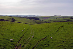
| 9:42p | Tracks of time. stokeyouth1 has added a photo to the pool:
Looking across the Derbyshire Dales towards Roystone Grange Farm from the High Peak Trail close to Minninglow in the Peak District National Park. It is shot from a bridge which spans a road between two fields |
| 9:42p | |
| 9:42p |


![[3083] Mendip, Somerset](https://live.staticflickr.com/65535/53247738072_6819140226_m.jpg)


| << Previous Day |
2023/10/10 [Calendar] |
Next Day >> |